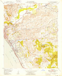
1949 Map of San Luis Rey
USGS Topo · Published 1949About this map
Mission San Luis Rey De Francia and the Academy of the Little Flower anchor the northern valley where the San Luis Rey River meets the coastal plain. In the years following the war, this coastal strip shows the rapid transition from ranching heritage to modern infrastructure, with the Oceanside Municipal Airport and Buddy Todd Memorial Park established near the growing town centers. The map details the northern reaches of Carlsbad and the sprawling Oceanside, where the Atchison Topeka and Santa Fe railroad tracks run parallel to the Coast Highway. To the north, the massive Camp Joseph H Pendleton Naval Reservation occupies the historic Santa Margarita Y Las Flores grant, marking a major shift in land use from the earlier 19th-century rancho period to mid-century military operations.
Find a feature on this map
53 named features on this map. Tap any name to fly to it.
Don’t see what you’re looking for? This feature index may not catch every label — zoom into the map to look around manually.
Map Details
Editions of this 1949 San Luis Rey Map
This is the sole edition of this map. No revisions or reprints were ever made.
Other maps of this area

1893 · Oceanside
USGS Topo · 1:62,500

1893 · Escondido
USGS Topo · 1:62,500

1898 · Oceanside
USGS Topo · 1:62,500

1901 · Escondido
USGS Topo · 1:62,500

1901 · Oceanside
USGS Topo · 1:62,500

1901 · San Luis Rey
USGS Topo · 1:125,000

1904 · Southern California Sheet No. 2
USGS Topo · 1:250,000

1941 · Margarita Peak
USGS Topo · 1:62,500

1942 · Margarita Peak
USGS Topo · 1:62,500

1942 · Temecula
USGS Topo · 1:62,500