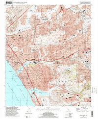
1997 Map of San Luis Rey
USGS Topo · Published 2000About this map
The historical Mission San Luis Rey de Francia anchors this coastal landscape, situated just south of the San Luis Rey River and the sprawling Camp Pendleton Marine Corps Base. The map reveals the late-20th-century expansion of Oceanside, Carlsbad, and Vista, illustrating a complex network of suburban development intertwined with significant topographical landmarks like Cerro de la Calavera and San Luis Rey Mesa.
Find a feature on this map
78 named features on this map. Tap any name to fly to it.
Don’t see what you’re looking for? This feature index may not catch every label — zoom into the map to look around manually.
Map Details
Editions of this 1997 San Luis Rey Map
This is the sole edition of this map. No revisions or reprints were ever made.
Other maps of this area

1893 · Oceanside
USGS Topo · 1:62,500

1893 · Escondido
USGS Topo · 1:62,500

1898 · Oceanside
USGS Topo · 1:62,500

1901 · Escondido
USGS Topo · 1:62,500

1901 · Oceanside
USGS Topo · 1:62,500

1901 · San Luis Rey
USGS Topo · 1:125,000

1904 · Southern California Sheet No. 2
USGS Topo · 1:250,000

1941 · Margarita Peak
USGS Topo · 1:62,500

1942 · Margarita Peak
USGS Topo · 1:62,500

1942 · Temecula
USGS Topo · 1:62,500