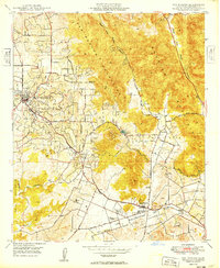
1949 Map of San Marcos
USGS Topo · Published 1949About this map
The San Marcos Mountains and Merriam Mountains dominate this northern San Diego County landscape, shaping the development of the valleys below. In the late 1940s, the region transitioned from rural grazing lands and orchards toward more established educational and infrastructure hubs, evidenced by the presence of Palomar Junior College and High School and the San Marcos Valley Airport. Transportation is anchored by the Atchison Topeka and Santa Fe railroad, which skirts the southern foothills near San Marcos.
Find a feature on this map
38 named features on this map. Tap any name to fly to it.
Don’t see what you’re looking for? This feature index may not catch every label — zoom into the map to look around manually.
Map Details
Editions of this 1949 San Marcos Map
This is the sole edition of this map. No revisions or reprints were ever made.
Other maps of this area

1893 · Oceanside
USGS Topo · 1:62,500

1893 · Escondido
USGS Topo · 1:62,500

1898 · Oceanside
USGS Topo · 1:62,500

1901 · Escondido
USGS Topo · 1:62,500

1901 · Oceanside
USGS Topo · 1:62,500

1901 · San Luis Rey
USGS Topo · 1:125,000

1904 · Southern California Sheet No. 2
USGS Topo · 1:250,000

1941 · Margarita Peak
USGS Topo · 1:62,500

1942 · Margarita Peak
USGS Topo · 1:62,500

1942 · Temecula
USGS Topo · 1:62,500