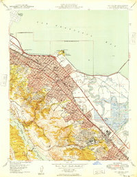
1949 Map of San Mateo
USGS Topo · Published 1949About this map
San Mateo and its mid-century neighbors appear here as a dense corridor of development pressed between the San Francisco Bay and the wooded heights of Buri Buri Ridge. This era shows a community in the midst of post-war growth, with the Southern Pacific railroad and the Bayshore Highway serving as primary transit arteries. The map captures a high concentration of institutional landmarks, from the sprawling campus of San Mateo Junior College to specialized facilities like the California Sanitarium and St Josephs Military Academy. To the west, the landscape shifts abruptly to the utility-oriented terrain of the Upper Crystal Springs Reservoir and Lower San Andreas Lake, while the eastern shore is defined by the wetlands of Brewer Island and the tidal reaches of Angelo Slough. This survey provides a precise look at the suburban expansion of Burlingame and Belmont before the late-century densification of the Peninsula.
Find a feature on this map
80 named features on this map. Tap any name to fly to it.
Don’t see what you’re looking for? This feature index may not catch every label — zoom into the map to look around manually.
Map Details
Editions of this 1949 San Mateo Map
This is the sole edition of this map. No revisions or reprints were ever made.
Other maps of this area

1892 · San Mateo
USGS Topo · 1:62,500

1896 · San Mateo
USGS Topo · 1:62,500

1897 · Palo Alto
USGS Topo · 1:62,500

1899 · Palo Alto
USGS Topo · 1:62,500

1899 · Haywards
USGS Topo · 1:62,500

1899 · San Mateo
USGS Topo · 1:62,500

1902 · Santa Cruz
USGS Topo · 1:125,000

1915 · San Mateo
USGS Topo · 1:62,500

1915 · Haywards
USGS Topo · 1:62,500

1939 · San Mateo
USGS Topo · 1:62,500