
1947 Map of San Miguel
USGS Topo · Published 1955About this map
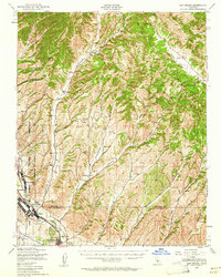
Camp Roberts dominates the southwestern portion of this Central Coast landscape, split by the Salinas River and the Southern Pacific Railroad. The town of San Miguel sits at the southern edge, where the tracks parallel U.S. 101 through a valley corridor that transitions quickly into the steep ridges of Middle Mountain and Stockdale Mtn. This 1947 survey captures the area at a peak of military activity, showing the East Garrison and Nacimiento support infrastructure alongside older agrarian roots.
Find a feature on this map
37 named features on this map. Tap any name to fly to it.
Don’t see what you’re looking for? This feature index may not catch every label — zoom into the map to look around manually.
Map Details
Editions of this 1947 San Miguel Map
2 editions found
Other maps of this area

1912 · Coalinga
USGS Topo · 1:125,000

1914 · Cholame
USGS Topo · 1:125,000

1915 · Priest Valley
USGS Topo · 1:125,000

1915 · Cholame
USGS Topo · 1:125,000

1917 · Cholame
USGS Topo · 1:125,000

1919 · San Miguel
USGS Topo · 1:62,500

1919 · Paso Robles
USGS Topo · 1:62,500

1919 · Bradley
USGS Topo · 1:62,500

1919 · Adelaida
USGS Topo · 1:62,500

1932 · Adelaida
USGS Topo · 1:62,500