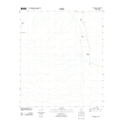
2011 Map of San Miguel
USGS Topo · Published 2011About this map
Baboquivari Valley dominates the eastern half of this borderlands survey, characterized by the winding path of Vamori Wash as it flows northward. The settlement of San Miguel sits at the northern end of this corridor, where Noriego Rd and Indian Rte 19 intersect. To the west, the desert landscape rises toward Morena Mountain and the feature known as Haivan Vaya. The map provides a detailed look at the rural infrastructure of the Chukut Kuk District, including the remote location of Hashan Chuchg and water resources like the San Miguel Tank. This area, situated along the Arizona-Sonora border, shows the sparse distribution of settlements and the importance of dry washes and small tanks in the arid environment.
Find a feature on this map
10 named features on this map. Tap any name to fly to it.
Don’t see what you’re looking for? This feature index may not catch every label — zoom into the map to look around manually.
Map Details
Editions of this 2011 San Miguel Map
This is the sole edition of this map. No revisions or reprints were ever made.
Other maps of this area

1941 · Presumido Peak
USGS Topo · 1:62,500

1941 · Vamori
USGS Topo · 1:62,500

1943 · Fresnal
USGS Topo · 1:125,000

1943 · Presumido Peak
USGS Topo · 1:62,500

1943 · Vamori
USGS Topo · 1:62,500

1956 · Nogales
USGS Topo · 1:250,000

1958 · Nogales
USGS Topo · 1:250,000

1959 · Nogales
USGS Topo · 1:250,000
1979 · San Miguel
USGS Topo · 1:24,000
1979 · Caponera Peak
USGS Topo · 1:24,000
Featured Places
- Chukut Kuk District, AZ
- San Miguel, Chukut Kuk District
- Haivan Vaya, Chukut Kuk District
- Hashan Chuchg, Chukut Kuk District
- Pima County, AZ