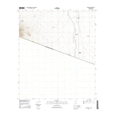
2014 Map of San Miguel
USGS Topo · Published 2014About this map
San Miguel sits at the northern edge of the international border between the United States and Mexico, anchoring a landscape where the Baboquivari Valley meets the high desert of Pima County. This 2014 survey documents a critical junction of geography and political boundary, where the line between the Arizona and Sonora, Mexico, is traced across the arid floor. The terrain is defined by the ephemeral Vamori Wash and the prominent rise of Morena Mtn to the west. Local infrastructure is sparse, characterized by vital water sources like San Miguel Tank and a network of desert routes including Bia-19 and Noriego Rd. The placement of Haivan Vaya and Hashan Chuchg illustrates the traditional settlement patterns of the Chukut Kuk District, showing how communities are positioned in relation to the valley's drainage and the neighboring mountain slopes.
Find a feature on this map
12 named features on this map. Tap any name to fly to it.
Don’t see what you’re looking for? This feature index may not catch every label — zoom into the map to look around manually.
Map Details
Editions of this 2014 San Miguel Map
This is the sole edition of this map. No revisions or reprints were ever made.
Other maps of this area

1941 · Presumido Peak
USGS Topo · 1:62,500

1941 · Vamori
USGS Topo · 1:62,500

1943 · Fresnal
USGS Topo · 1:125,000

1943 · Presumido Peak
USGS Topo · 1:62,500

1943 · Vamori
USGS Topo · 1:62,500

1956 · Nogales
USGS Topo · 1:250,000

1958 · Nogales
USGS Topo · 1:250,000

1959 · Nogales
USGS Topo · 1:250,000
1979 · San Miguel
USGS Topo · 1:24,000
1979 · Caponera Peak
USGS Topo · 1:24,000
Featured Places
- Chukut Kuk District, AZ
- San Miguel, Chukut Kuk District
- Haivan Vaya, Chukut Kuk District
- Hashan Chuchg, Chukut Kuk District
- Pima County, AZ