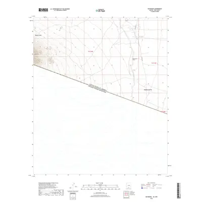
2018 Map of San Miguel
USGS Topo · Published 2018About this map
The Baboquivari Valley defines the landscape of this Pima County border region, where the desert floor is marked by the complex drainage of the Vamori Wash. This 2018 survey captures a remote section of the Tohono O'odham Nation, documenting the enduring presence of small settlements like Haivan Vaya and Hashan Chuchg. The most significant geographic feature is the international boundary between the United States of America and Estados Unidos Mexicanos, which cuts diagonally across the terrain. Local travel is facilitated by a sparse network of roads, including San Miguel Rd and Noriego Rd, while the San Miguel Tank indicates the essential role of water management in this arid environment. To the northwest, the elevation rises sharply toward the slopes of Morena Mtn, providing a distinct contrast to the alluvial plains below.
Find a feature on this map
12 named features on this map. Tap any name to fly to it.
Don’t see what you’re looking for? This feature index may not catch every label — zoom into the map to look around manually.
Map Details
Editions of this 2018 San Miguel Map
This is the sole edition of this map. No revisions or reprints were ever made.
Other maps of this area

1941 · Presumido Peak
USGS Topo · 1:62,500

1941 · Vamori
USGS Topo · 1:62,500

1943 · Fresnal
USGS Topo · 1:125,000

1943 · Presumido Peak
USGS Topo · 1:62,500

1943 · Vamori
USGS Topo · 1:62,500

1956 · Nogales
USGS Topo · 1:250,000

1958 · Nogales
USGS Topo · 1:250,000

1959 · Nogales
USGS Topo · 1:250,000
1979 · San Miguel
USGS Topo · 1:24,000
1979 · Caponera Peak
USGS Topo · 1:24,000
Featured Places
- Chukut Kuk District, AZ
- San Miguel, Chukut Kuk District
- Haivan Vaya, Chukut Kuk District
- Hashan Chuchg, Chukut Kuk District
- Pima County, AZ