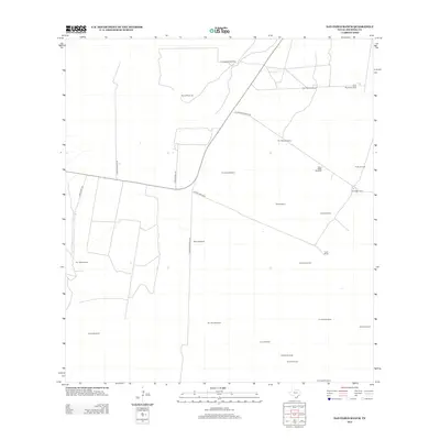
2013 Map of San Pablo Ranch
USGS Topo · Published 2013About this map
San Pablo Ranch anchors a landscape defined by the deep-rooted ranching heritage of Jim Hogg County. This survey illustrates the vital infrastructure of the South Texas brush country, where isolated outposts like San Rafael Ranch and Lyton Ranch are connected by a network of private roads including Lytton Ranch Rd and El Milagro Ranch Rd. The proliferation of named water sources, such as San Pedro Windmill, Maria Stella Windmill, and Pablo Blanco Windmill, emphasizes the critical nature of water management in this arid region. Industrial activity is present at the Prado Oil Field in the northeast, marking a shift from traditional cattle ranching to petroleum extraction. This map serves as a detailed record of land ownership and utility for researchers interested in the territorial history and resource development of the South Texas plains during the early 21st century.
Find a feature on this map
29 named features on this map. Tap any name to fly to it.
Don’t see what you’re looking for? This feature index may not catch every label — zoom into the map to look around manually.
Map Details
Editions of this 2013 San Pablo Ranch Map
This is the sole edition of this map. No revisions or reprints were ever made.
Other maps of this area

1938 · Agua Nueva
USGS Topo · 1:62,500

1938 · Cuevitas
USGS Topo · 1:62,500

1939 · Randado
USGS Topo · 1:62,500

1940 · Randado
USGS Topo · 1:62,500

1949 · Mc Allen
USGS Topo · 1:250,000

1954 · McAllen
USGS Topo · 1:250,000

1956 · Laredo
USGS Topo · 1:250,000

1957 · Mc Allen
USGS Topo · 1:250,000

1962 · McAllen
USGS Topo · 1:250,000

1972 · Armstrong Ranch
USGS Topo · 1:24,000