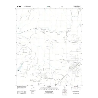
2012 Map of San Pasqual
USGS Topo · Published 2012About this map
Santa Maria Valley and the western edge of Ramona anchor the southeastern corner of this map, where the suburban grid transitions into the steep terrain of the Peninsular Ranges. The landscape is defined by the significant drainage of Santa Ysabel Cr which flows through the San Pasqual valley, passing landmark features like Rockwood Canyon and Schoolhouse Canyon. To the south, Woodson Mountain rises sharply, topped by the Woodson Mountain Lookout, providing a strategic vantage point over the network of ranch roads and modern developments. The map documents a specific moment in the rural-suburban evolution of San Diego County, showing the proximity of agricultural heritage sites like Fenton Ranch to infrastructure like the Ramona Airport and Ramona Heli-Tack. Smaller settlements such as Rosemont and topographical markers like Cranes Peak further define the varied geography of this inland region.
Find a feature on this map
100 named features on this map. Tap any name to fly to it.
Don’t see what you’re looking for? This feature index may not catch every label — zoom into the map to look around manually.
Map Details
Editions of this 2012 San Pasqual Map
This is the sole edition of this map. No revisions or reprints were ever made.
Other maps of this area

1893 · El Cajon
USGS Topo · 1:62,500

1893 · Escondido
USGS Topo · 1:62,500

1901 · Elcajon
USGS Topo · 1:62,500

1901 · Escondido
USGS Topo · 1:62,500

1901 · San Luis Rey
USGS Topo · 1:125,000

1903 · Cuyamaca
USGS Topo · 1:125,000

1903 · La Jolla
USGS Topo · 1:62,500

1903 · Elcajon
USGS Topo · 1:62,500

1903 · Ramona
USGS Topo · 1:125,000

1904 · Southern California Sheet No. 2
USGS Topo · 1:250,000