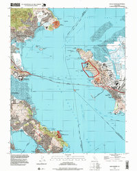
1995 Map of San Quentin
USGS Topo · Published 1999About this map
San Quentin State Prison stands as a prominent fixture on the western shore of the San Pablo Strait, connected to the industrial waterfront of Richmond by the Richmond-San Rafael Bridge. This mid-1990s geography captures a complex maritime landscape where military and industrial infrastructure, such as the Naval Fuel Supply Depot at Point Molate, exists alongside preserved natural spaces like the Corte Madera Marsh State Ecological Reserve and China Camp State Park.
Find a feature on this map
62 named features on this map. Tap any name to fly to it.
Don’t see what you’re looking for? This feature index may not catch every label — zoom into the map to look around manually.
Map Details
Editions of this 1995 San Quentin Map
This is the sole edition of this map. No revisions or reprints were ever made.
Other maps of this area

1895 · San Francisco
USGS Topo · 1:62,500

1897 · Tamalpais
USGS Topo · 1:62,500

1899 · San Francisco
USGS Topo · 1:62,500

1902 · Napa
USGS Topo · 1:125,000

1914 · Petaluma
USGS Topo · 1:62,500

1915 · San Francisco
USGS Topo · 1:62,500

1916 · Mare Island
USGS Topo · 1:62,500

1941 · Tamalpais
USGS Topo · 1:62,500

1942 · Mare Island
USGS Topo · 1:62,500

1942 · Petaluma
USGS Topo · 1:62,500