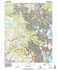
1993 Map of San Rafael
USGS Topo · Published 1997About this map
San Rafael and its neighboring valley communities are presented in this 1993 revision, showcasing the complex interface between suburban development and preserved wildlands in Marin County. The map details the dense residential patterns of Mill Valley and Corte Madera as they climb the lower slopes of the ridges toward Mount Tamalpais. Notable cultural landmarks like the Mt Tamalpais Cemetery and academic institutions such as Dominican College and the College of Marin anchor the developed areas.
Find a feature on this map
81 named features on this map. Tap any name to fly to it.
Don’t see what you’re looking for? This feature index may not catch every label — zoom into the map to look around manually.
Map Details
Editions of this 1993 San Rafael Map
This is the sole edition of this map. No revisions or reprints were ever made.
Other maps of this area

1895 · San Francisco
USGS Topo · 1:62,500

1897 · Tamalpais
USGS Topo · 1:62,500

1899 · San Francisco
USGS Topo · 1:62,500

1902 · Napa
USGS Topo · 1:125,000

1914 · Petaluma
USGS Topo · 1:62,500

1915 · San Francisco
USGS Topo · 1:62,500

1916 · Mare Island
USGS Topo · 1:62,500

1941 · Tamalpais
USGS Topo · 1:62,500

1942 · Mare Island
USGS Topo · 1:62,500

1942 · Petaluma
USGS Topo · 1:62,500