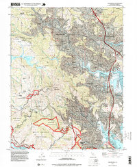
1995 Map of San Rafael
USGS Topo · Published 1999About this map
Mount Tamalpais and the surrounding canyons define this coastal landscape, where the ridges descend toward the interconnected waters of Richardson Bay and San Francisco Bay. By the mid-1990s, the dense suburban fabric of San Rafael, San Anselmo, and Mill Valley had fully integrated with the protected lands of Muir Woods National Monument and the Golden Gate National Recreation Area. The map reveals a complex institutional geography, from the San Francisco Theological Seminary in San Anselmo to the Tamalpais School for Boys and the Military Academy. Along the shoreline, the Corte Madera Marsh State Ecological Reserve provides a contrast to the developed marinas and settlements like Marin City and Corte Madera. Historic recreation sites, including Camp Lilienthal and Tamaranch Camp, are tucked into the drainages of Fairfax Creek and Cascade Creek.
Find a feature on this map
100 named features on this map. Tap any name to fly to it.
Don’t see what you’re looking for? This feature index may not catch every label — zoom into the map to look around manually.
Map Details
Editions of this 1995 San Rafael Map
This is the sole edition of this map. No revisions or reprints were ever made.
Other maps of this area

1895 · San Francisco
USGS Topo · 1:62,500

1897 · Tamalpais
USGS Topo · 1:62,500

1899 · San Francisco
USGS Topo · 1:62,500

1902 · Napa
USGS Topo · 1:125,000

1914 · Petaluma
USGS Topo · 1:62,500

1915 · San Francisco
USGS Topo · 1:62,500

1916 · Mare Island
USGS Topo · 1:62,500

1941 · Tamalpais
USGS Topo · 1:62,500

1942 · Mare Island
USGS Topo · 1:62,500

1942 · Petaluma
USGS Topo · 1:62,500