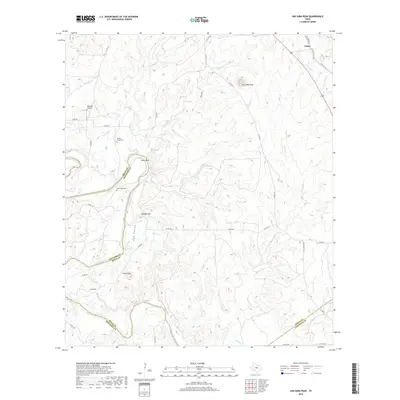
2019 Map of San Saba Peak
USGS Topo · Published 2019About this map
Colorado River frontage and the rugged uplands of the Texas hill country define this landscape, where the borders of Mills, San Saba, and Lampasas counties converge. The small settlement of Castor anchors the northeastern corner, situated along the Old Lometa Hwy. Throughout the terrain, rural history is preserved in family and geographic landmarks such as Nabors Creek Cem and Shaw Bend Cem. Significant elevation changes are marked by San Saba Peak and Green Mtn, while Rye Valley and Vinegar Hill provide distinct topographic variety between the river's winding course and the numerous creek drainages. The presence of Edwards Airport and a network of county roads, including Co RD 411 and Co RD 143, show the modern infrastructure layered over this traditionally pastoral region.
Find a feature on this map
42 named features on this map. Tap any name to fly to it.
Don’t see what you’re looking for? This feature index may not catch every label — zoom into the map to look around manually.
Map Details
Editions of this 2019 San Saba Peak Map
This is the sole edition of this map. No revisions or reprints were ever made.
Other maps of this area

1885 · San Saba
USGS Topo · 1:125,000

1887 · Lampasas
USGS Topo · 1:125,000

1894 · Lampasas
USGS Topo · 1:125,000

1894 · San Saba
USGS Topo · 1:125,000

1925 · San Saba 4-a
USGS Topo · 1:48,000

1925 · San Saba 1-c
USGS Topo · 1:48,000

1925 · San Saba 1-b
USGS Topo · 1:48,000

1925 · San Saba 1-d
USGS Topo · 1:48,000

1928 · Goldthwaite
USGS Topo · 1:62,500

1931 · Bend
USGS Topo · 1:62,500