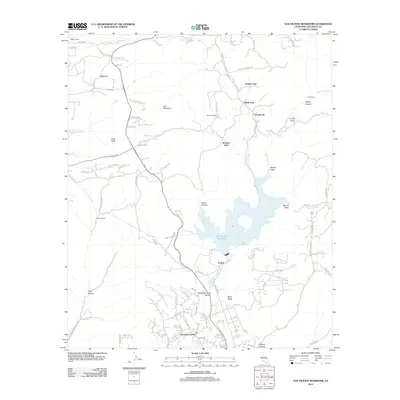
2012 Map of San Vicente Reservoir
USGS Topo · Published 2012About this map
San Vicente Reservoir dominates the center of this 2012 survey, its multi-lobed shoreline defining the transition between the coastal foothills and the deeper inland canyons of San Diego County. To the north and west, the landscape is marked by a series of named ranch properties, including Warren Ranch, Wildwood Ranch, and Goodan Ranch, reflecting the area's pastoral history amidst increasingly subdivided residential clusters like Eucalyptus Hills. The geography is defined by steep relief, where summits such as Goat Peak and Iron Mountain tower over drainage systems like Poway Creek and the West Branch San Vicente Creek. Small communities such as Fernbrook, Shady Dell, and Boulder Oaks sit along these watercourses, illustrating the early 21st-century settlement patterns where rural homesteads and newer developments meet the protected water resources of the reservoir.
Find a feature on this map
81 named features on this map. Tap any name to fly to it.
Don’t see what you’re looking for? This feature index may not catch every label — zoom into the map to look around manually.
Map Details
Editions of this 2012 San Vicente Reservoir Map
This is the sole edition of this map. No revisions or reprints were ever made.
Other maps of this area

1893 · El Cajon
USGS Topo · 1:62,500

1893 · Escondido
USGS Topo · 1:62,500

1901 · Elcajon
USGS Topo · 1:62,500

1901 · Escondido
USGS Topo · 1:62,500

1901 · San Luis Rey
USGS Topo · 1:125,000

1903 · Cuyamaca
USGS Topo · 1:125,000

1903 · La Jolla
USGS Topo · 1:62,500

1903 · Elcajon
USGS Topo · 1:62,500

1903 · Ramona
USGS Topo · 1:125,000

1904 · Southern California Sheet No. 2
USGS Topo · 1:250,000