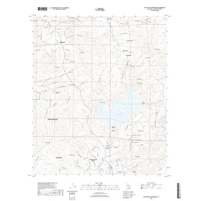
2018 Map of San Vicente Reservoir
USGS Topo · Published 2018About this map
The San Vicente Reservoir dominates this high-detail 2018 survey, serving as a central hydrological landmark for the surrounding canyons and residential developments. Located at the intersection of various foothill communities, the map provides a look at the modern suburban and rural footprint of Poway, Santee, and Eucalyptus Hills. The complex geography is defined by numerous drainage systems including Sycamore Canyon and Slaughterhouse Canyon, which funnel toward the reservoir and the San Diego Aqueduct. Local elevation points like Iron Mtn and Goat Peak provide clear reference markers for the residential clusters at Fernbrook and Shady Dell. This map records the contemporary extent of trail networks such as the Iron Mountain Peak Trail and Ellie Lane Trail, illustrating the integration of recreation and open space within the inland San Diego County landscape.
Find a feature on this map
116 named features on this map. Tap any name to fly to it.
Don’t see what you’re looking for? This feature index may not catch every label — zoom into the map to look around manually.
Map Details
Editions of this 2018 San Vicente Reservoir Map
This is the sole edition of this map. No revisions or reprints were ever made.
Other maps of this area

1893 · El Cajon
USGS Topo · 1:62,500

1893 · Escondido
USGS Topo · 1:62,500

1901 · Elcajon
USGS Topo · 1:62,500

1901 · Escondido
USGS Topo · 1:62,500

1901 · San Luis Rey
USGS Topo · 1:125,000

1903 · Cuyamaca
USGS Topo · 1:125,000

1903 · La Jolla
USGS Topo · 1:62,500

1903 · Elcajon
USGS Topo · 1:62,500

1903 · Ramona
USGS Topo · 1:125,000

1904 · Southern California Sheet No. 2
USGS Topo · 1:250,000