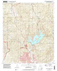
1996 Map of San Vicente Reservoir
USGS Topo · Published 2001About this map
San Vicente Reservoir dominates the eastern half of this landscape, its irregular shoreline reaching into the deep drainages of Kimball Valley and San Vicente Creek. The 1996 planimetry shows a region defined by its varied land use, where the residential pockets of Eucalyptus Hills and Moreno sit south of the protected wildlands of the Sycamore Canyon Open Space Preserve. To the west, the Marine Corps Air Station Miramar Sycamore Canyon Annex indicates the area's strategic importance, while the interior is dotted with historical ranching names like Wildwood Ranch and Goodan Ranch. Prominent peaks like Iron Mtn and Goat Pk rise above the network of primitive trails and fire breaks, such as the Foster Truck Trail, which navigate the steep terrain between the valleys and the reservoir's Resort Area.
Find a feature on this map
51 named features on this map. Tap any name to fly to it.
Don’t see what you’re looking for? This feature index may not catch every label — zoom into the map to look around manually.
Map Details
Editions of this 1996 San Vicente Reservoir Map
This is the sole edition of this map. No revisions or reprints were ever made.
Other maps of this area

1893 · El Cajon
USGS Topo · 1:62,500

1893 · Escondido
USGS Topo · 1:62,500

1901 · Elcajon
USGS Topo · 1:62,500

1901 · Escondido
USGS Topo · 1:62,500

1901 · San Luis Rey
USGS Topo · 1:125,000

1903 · Cuyamaca
USGS Topo · 1:125,000

1903 · La Jolla
USGS Topo · 1:62,500

1903 · Elcajon
USGS Topo · 1:62,500

1903 · Ramona
USGS Topo · 1:125,000

1904 · Southern California Sheet No. 2
USGS Topo · 1:250,000