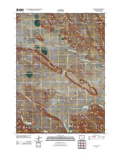
2011 Map of Sand Gap
USGS Topo · Published 2011About this map
Virginia Valley and Anderson Valley dominate this high-desert landscape in Harney County, where the ranching economy is etched into the terrain. The South Fork Malheur River cuts across the northern section, supported by water management features like Mahon Reservoir and Jenkins Reservoir. This digital-era survey documents a network of rural roads, including the Old Hwy and Virginia Valley Rd, connecting working lands such as the Tom Jenkins Ranch and Anderson Valley Ranch. Notable geographic landmarks like Sand Gap and the curiously named Hole-in-the-Ground provide orientation in this vast basin. The map illustrates how seasonal water sources like Buster Creek and Camp Creek dictate the placement of livestock operations and homesteads within the shadow of the Round Mountains.
Find a feature on this map
17 named features on this map. Tap any name to fly to it.
Don’t see what you’re looking for? This feature index may not catch every label — zoom into the map to look around manually.
Map Details
Editions of this 2011 Sand Gap Map
This is the sole edition of this map. No revisions or reprints were ever made.
Other maps of this area

1955 · Burns
USGS Topo · 1:250,000

1958 · Burns
USGS Topo · 1:250,000

1959 · Burns
USGS Topo · 1:250,000

1960 · Crane
USGS Topo · 1:62,500

1967 · Happy Valley
USGS Topo · 1:24,000

1967 · Adobe Flat
USGS Topo · 1:24,000

1968 · Venator
USGS Topo · 1:62,500

1972 · Circle Bar
USGS Topo · 1:24,000

1972 · Venator
USGS Topo · 1:24,000

1974 · Anderson Mtn
USGS Topo · 1:62,500