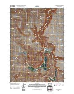
2011 Map of Sand Hollow
USGS Topo · Published 2011About this map
The South Fork Crooked River and its intricate drainage network define this high-desert ranching landscape in Crook County, Oregon. Water management is the primary narrative of this arid region, as seen through the numerous specialized features like Furnace Waterhole, Division Waterhole, and South Dagus Reservoir that sustain local livestock operations. The map documents long-standing family landholdings such as Coffelt Ranch and Cold Spring Ranch, providing a clear record of rural settlement patterns along the river and Twelvemile Creek. The terrain is marked by significant elevation changes, from the heights of Steens Ridge and Orr Point down through Sheep Head Canyon. Roads like Se Gi RD and Se Price Twelve Mile RD connect these isolated outposts across the Sand Hollow basin.
Find a feature on this map
24 named features on this map. Tap any name to fly to it.
Don’t see what you’re looking for? This feature index may not catch every label — zoom into the map to look around manually.
Map Details
Editions of this 2011 Sand Hollow Map
This is the sole edition of this map. No revisions or reprints were ever made.
Other maps of this area

1932 · Dayville
USGS Topo · 1:125,000

1936 · Dayville
USGS Topo · 1:125,000

1955 · Crescent
USGS Topo · 1:250,000

1955 · Bend
USGS Topo · 1:250,000

1955 · Burns
USGS Topo · 1:250,000

1955 · Canyon City
USGS Topo · 1:250,000

1957 · Crescent
USGS Topo · 1:250,000

1957 · Bend
USGS Topo · 1:250,000

1958 · Crescent
USGS Topo · 1:250,000

1958 · Burns
USGS Topo · 1:250,000