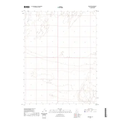
2023 Map of Sand Ridge
USGS Topo · Published 2023About this map
Sand Ridge and Beaver Ridge dominate the landscape of this central Millard County map, representing the varied geological formations of the Sevier Desert. The Beaver River enters from the northwest, though its presence here illustrates the characteristic drainage patterns of the Great Basin where water often disperses into desert sinks. This 2023 survey provides a clear view of the public land survey system grid across this open terrain, revealing how the township and range lines have structured the land management of the region for generations. For those studying the hydrography and elevation changes of the area, the map offers precise detail on the contours of the ridges and the shifting path of the riverbed.
Find a feature on this map
3 named features on this map. Tap any name to fly to it.
Don’t see what you’re looking for? This feature index may not catch every label — zoom into the map to look around manually.
Map Details
Editions of this 2023 Sand Ridge Map
This is the sole edition of this map. No revisions or reprints were ever made.
Other maps of this area

1885 · Beaver
USGS Topo · 1:250,000

1885 · Sevier Desert
USGS Topo · 1:250,000

1953 · Richfield
USGS Topo · 1:250,000

1953 · Delta
USGS Topo · 1:250,000

1958 · Richfield
USGS Topo · 1:250,000

1958 · Delta
USGS Topo · 1:250,000

1962 · Delta
USGS Topo · 1:250,000

1962 · Tabernacle Hill
USGS Topo · 1:62,500

1971 · Neels
USGS Topo · 1:24,000
1971 · Clear Lake
USGS Topo · 1:24,000