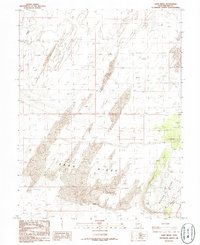
1986 Map of Sand Ridge
USGS Topo · Published 1986About this map
Beaver River winds through the northwestern corner of this high-desert landscape in central Millard County. The terrain is dominated by prominent geological formations, most notably the wide expanse of Sand Ridge and the distinct elevation of Beaver Ridge to the southeast. Compiled from aerial photography and field-checked in the early 1980s, this document captures a sparse and primarily unpopulated territory defined by its shifting topography rather than human settlement. Surveyors recorded specific benchmark elevations such as BM 4785 and BM 4870, providing precise vertical data for a region characterized by its expansive ridges and dry desert flats.
Find a feature on this map
7 named features on this map. Tap any name to fly to it.
Don’t see what you’re looking for? This feature index may not catch every label — zoom into the map to look around manually.
Map Details
Editions of this 1986 Sand Ridge Map
This is the sole edition of this map. No revisions or reprints were ever made.
Other maps of this area

1885 · Beaver
USGS Topo · 1:250,000

1885 · Sevier Desert
USGS Topo · 1:250,000

1953 · Richfield
USGS Topo · 1:250,000

1953 · Delta
USGS Topo · 1:250,000

1958 · Richfield
USGS Topo · 1:250,000

1958 · Delta
USGS Topo · 1:250,000

1962 · Delta
USGS Topo · 1:250,000

1962 · Tabernacle Hill
USGS Topo · 1:62,500

1971 · Neels
USGS Topo · 1:24,000
1971 · Clear Lake
USGS Topo · 1:24,000