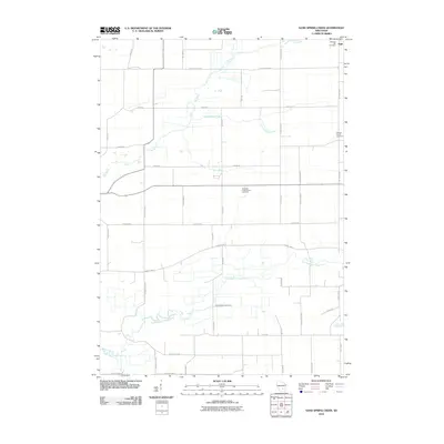
2010 Map of Sand Spring Creek
USGS Topo · Published 2010About this map
The Fox River meanders across the northern reaches of this Columbia County landscape, defining a terrain shaped by glacial watercourses and settled farming tracts. In the northeast corner, the small settlement of Ingle sits near Pleasant Hill Cemetery, while the broader agricultural plain is dotted with sites of local heritage including the Portage Prairie Cemetery and Rosedale Presbyterian Cemetery. The hydrology of the area is distinct, with Sand Spring Creek flowing through the central section and the North Branch Duck Creek tracing an intricate path across the southern half. A dense grid of rural roads, such as Vaughn Rd and County Hwy-P, connects these scattered landmarks, reflecting the organized land use of the early 21st century. The map provides a detailed view of the drainage patterns and historical burial grounds that anchor this rural Wisconsin community.
Find a feature on this map
37 named features on this map. Tap any name to fly to it.
Don’t see what you’re looking for? This feature index may not catch every label — zoom into the map to look around manually.
Map Details
Editions of this 2010 Sand Spring Creek Map
This is the sole edition of this map. No revisions or reprints were ever made.
Other maps of this area

1901 · Poynette
USGS Topo · 1:62,500

1902 · Portage
USGS Topo · 1:62,500

1955 · Randolph
USGS Topo · 1:62,500

1955 · Columbus
USGS Topo · 1:62,500

1957 · Madison
USGS Topo · 1:250,000

1960 · Madison
USGS Topo · 1:250,000

1962 · Poynette
USGS Topo · 1:62,500

1962 · Portage
USGS Topo · 1:62,500
1980 · Manchester
USGS Topo · 1:24,000
1980 · Rio
USGS Topo · 1:24,000