
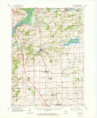
1962 Map of Poynette
USGS Topo · Published 1964About this map
Poynette and the surrounding townships of Arlington and Leeds occupy a landscape shaped by glacial legacy and early Wisconsin settlement. The Wisconsin River defines the western edge, featuring Lib Cross Island and the prominent heights of Whites Bluff. Inland, the map reveals a sophisticated agricultural network anchored by the University of Wisconsin Experimental Farm and numerous rural schools like Empire Prairie Sch and LaFollette Sch.
Find a feature on this map
70 named features on this map. Tap any name to fly to it.
Don’t see what you’re looking for? This feature index may not catch every label — zoom into the map to look around manually.
Map Details
Editions of this 1962 Poynette Map
2 editions found
Other maps of this area

1890 · Madison
USGS Topo · 1:62,500

1890 · Sun Prairie
USGS Topo · 1:62,500

1892 · Madison
USGS Topo · 1:62,500

1895 · Baraboo
USGS Topo · 1:62,500

1896 · Sun Prairie
USGS Topo · 1:62,500

1901 · Poynette
USGS Topo · 1:62,500

1902 · Portage
USGS Topo · 1:62,500

1902 · Briggsville
USGS Topo · 1:62,500

1904 · Madison
USGS Topo · 1:62,500

1905 · Sun Prairie
USGS Topo · 1:62,500