
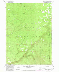
1966 Map of Sandhill Crossing
USGS Topo · Published 1968About this map
Fremont National Forest defines this high-elevation landscape in the mid-1960s, where the North Fork Sprague River and its tributaries like Boulder Creek and Paradise Creek carve through the Klamath and Lake County borderlands. The map documents a period when the timber and ranching history of the region is evident through remote outposts and livestock management points. Notable locations include the B K Corrals and the isolated Conrad Place to the north, while the Ryan Cabin sits tucked away near several nameless Springs. Geographically, the terrain is anchored by significant peaks including Black Butte and Green Mountain, descending toward the river valley where Sandhill Crossing provides a key point of transit and recreation at the Sandhill Campground. To the southeast, the protected slopes of the Gearhart Mountain Wilderness rise toward the summit of Gearhart Mtn.
Find a feature on this map
30 named features on this map. Tap any name to fly to it.
Don’t see what you’re looking for? This feature index may not catch every label — zoom into the map to look around manually.
Map Details
Editions of this 1966 Sandhill Crossing Map
2 editions found
Other maps of this area

1889 · Klamath
USGS Topo · 1:250,000

1894 · Klamath
USGS Topo · 1:250,000

1955 · Klamath Falls
USGS Topo · 1:250,000

1958 · Klamath Falls
USGS Topo · 1:250,000

1960 · Riverbed Butte
USGS Topo · 1:62,500

1960 · Bly
USGS Topo · 1:62,500

1960 · Fishhole Mtn
USGS Topo · 1:62,500

1966 · Shake Butte
USGS Topo · 1:24,000

1966 · Harvey Creek
USGS Topo · 1:24,000

1966 · Lee Thomas Crossing
USGS Topo · 1:24,000