
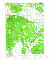
1960 Map of Bly
USGS Topo · Published 1961About this map
Bly serves as the primary hub in this corner of Klamath County, situated where the North Fork Sprague River and South Fork Sprague River converge. The landscape is defined by the high timber of the Fremont National Forest, dominated by peaks like Medicine Mountain and Ferguson Mountain. Evidence of the mid-century timber and ranching economy is visible throughout, from the Ivory Pine Mill (Site) to the sprawling operations of Vinson Ranch and Gerber Ranch. Transportation follows the water, with the Oregon California and Eastern Railroad winding through the Sprague River Valley past Sycan Siding. The map details an intricate network of water management features essential for the high-desert climate, including Whitmore Reservoir and the O'Connor Reservoir, alongside historic family-named burial grounds like Masekesket Cem.
Find a feature on this map
82 named features on this map. Tap any name to fly to it.
Don’t see what you’re looking for? This feature index may not catch every label — zoom into the map to look around manually.
Map Details
Editions of this 1960 Bly Map
2 editions found
Other maps of this area

1889 · Klamath
USGS Topo · 1:250,000

1894 · Klamath
USGS Topo · 1:250,000

1955 · Klamath Falls
USGS Topo · 1:250,000

1957 · Malin
USGS Topo · 1:62,500

1958 · Klamath Falls
USGS Topo · 1:250,000

1960 · Gerber Reservoir
USGS Topo · 1:62,500

1960 · Riverbed Butte
USGS Topo · 1:62,500

1960 · Strawberry Butte
USGS Topo · 1:62,500

1960 · Beatty
USGS Topo · 1:62,500

1960 · Fuego Mountain
USGS Topo · 1:62,500