
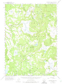
1960 Map of Strawberry Butte
USGS Topo · Published 1961About this map
Strawberry Butte rises above the high desert landscape of Fremont National Forest, marking a region defined by its reliance on seasonal water and cattle ranching during the mid-twentieth century. This survey of the Oregon and California borderlands reveals a network of isolated outposts such as Hunt Ranch, Lapham Ranch, and Devault Ranch. The landscape is etched with the transition from traditional wagon routes like the Old Stage Road to modern forest infrastructure, including the Barnes Valley Guard Station and State Line Guard Station. Numerous small reservoirs and springs, such as Little Squaw Flat Reservoir and Arkansas Reservoir, reflect the intensive water management necessary for livestock in this arid terrain. Topographical landmarks like Juniper Mountain and Harp Mountain overlook broad flats and meadows, including Sorghum Flat and Holmes Meadow, providing a detailed view of the remote ranching and forest service heritage of Lake and Klamath counties.
Find a feature on this map
133 named features on this map. Tap any name to fly to it.
Don’t see what you’re looking for? This feature index may not catch every label — zoom into the map to look around manually.
Map Details
Editions of this 1960 Strawberry Butte Map
2 editions found
Other maps of this area

1886 · Alturas
USGS Topo · 1:250,000

1886 · Modoc Lava Bed
USGS Topo · 1:250,000

1889 · Klamath
USGS Topo · 1:250,000

1892 · Modoc Lava-Bed
USGS Topo · 1:250,000

1892 · Alturas
USGS Topo · 1:250,000

1894 · Klamath
USGS Topo · 1:250,000

1951 · Clear Lake Reservoir
USGS Topo · 1:62,500

1954 · Alturas
USGS Topo · 1:250,000

1955 · Klamath Falls
USGS Topo · 1:250,000

1958 · Alturas
USGS Topo · 1:250,000