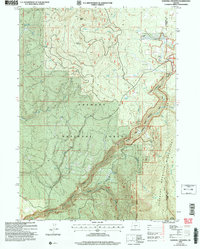
2004 Map of Sandhill Crossing
USGS Topo · Published 2007About this map
Fremont National Forest dominates this high-elevation landscape along the border of Klamath and Lake counties. The topography is defined by significant volcanic peaks including Black Butte and Green Mountain, which rise above a network of drainages that feed the Sprague River. The southeastern quadrant transition into the Gearhart Mountain Wilderness, where the Gearhart Mountain Trail winds through the headwaters of Gearhart Creek. Historical land use is evidenced by remote outposts and local landmarks like Conrad Place, Ryan Cabin, and the BK Corral. The area’s hydrological importance is clear from the density of named water sources such as Last Chance Spring, Cold Spring, and the North Fork Sprague River, which provide critical water in this timbered terrain.
Find a feature on this map
28 named features on this map. Tap any name to fly to it.
Don’t see what you’re looking for? This feature index may not catch every label — zoom into the map to look around manually.
Map Details
Editions of this 2004 Sandhill Crossing Map
This is the sole edition of this map. No revisions or reprints were ever made.
Other maps of this area

1889 · Klamath
USGS Topo · 1:250,000

1894 · Klamath
USGS Topo · 1:250,000

1955 · Klamath Falls
USGS Topo · 1:250,000

1958 · Klamath Falls
USGS Topo · 1:250,000

1960 · Riverbed Butte
USGS Topo · 1:62,500

1960 · Bly
USGS Topo · 1:62,500

1960 · Fishhole Mtn
USGS Topo · 1:62,500

1966 · Shake Butte
USGS Topo · 1:24,000

1966 · Sandhill Crossing
USGS Topo · 1:24,000

1966 · Harvey Creek
USGS Topo · 1:24,000