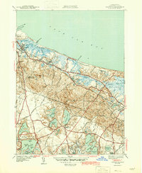
1943 Map of Sandwich
USGS Topo · Published 1943About this map
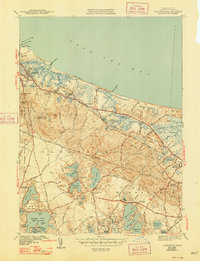
The New York New Haven and Hartford railroad tracks parallel the Cape Cod Bay shoreline, serving as the spine of coastal connectivity for Sandwich and East Sandwich. This early 1940s landscape is defined by the transition from the Great Marshes and Sandy Neck dunes to the densely clustered ponds of the interior, including Spectacle Pond and Lawrence Pond. Local history and genealogy are anchored by several family-named burial grounds like Tobey Cem and Percival Cem, while the community’s heritage is visible at the Old Quaker Meetinghouse and Wing Sch. The presence of the State Fish Hatchery and the Telegraph Hill Fire Tower reflects the era's focus on resource management and maritime observation along the Cape Cod Canal.
Find a feature on this map
65 named features on this map. Tap any name to fly to it.
Don’t see what you’re looking for? This feature index may not catch every label — zoom into the map to look around manually.
Map Details
Editions of this 1943 Sandwich Map
5 editions found
Other maps of this area

1886 · Falmouth
USGS Topo · 1:62,500

1886 · Plymouth
USGS Topo · 1:62,500

1888 · Barnstable
USGS Topo · 1:62,500

1888 · Falmouth
USGS Topo · 1:62,500

1889 · Plymouth
USGS Topo · 1:62,500

1893 · Barnstable
USGS Topo · 1:62,500

1893 · Falmouth
USGS Topo · 1:62,500

1894 · Plymouth
USGS Topo · 1:62,500

1915 · Falmouth
USGS Topo · 1:62,500

1920 · Falmouth
USGS Topo · 1:62,500