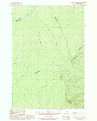
1989 Map of Sandy Bay Mountain
USGS Topo · Published 1989About this map
Sandy Bay Mountain rises as a prominent landmark along the international boundary between Quebec and Maine in this late-century survey. The landscape is defined by the headwaters of major drainage systems, including the Penobscot River and several international water bodies such as Rivière Linière and Ruisseau Lindsay. The map illustrates the complex surveyor townships of Blake Gore and Sandy Bay, highlighting the intersection of political and natural boundaries.
Find a feature on this map
23 named features on this map. Tap any name to fly to it.
Don’t see what you’re looking for? This feature index may not catch every label — zoom into the map to look around manually.
Map Details
Editions of this 1989 Sandy Bay Mountain Map
This is the sole edition of this map. No revisions or reprints were ever made.
Other maps of this area

1923 · Attean
USGS Topo · 1:62,500

1925 · Attean
USGS Topo · 1:62,500

1927 · Sandy Bay
USGS Topo · 1:48,000

1928 · Skinner
USGS Topo · 1:48,000

1930 · Sandy Bay
USGS Topo · 1:62,500

1931 · Skinner
USGS Topo · 1:62,500

1944 · Sandy Bay
USGS Topo · 1:62,500

1949 · Jackman
USGS Topo · 1:250,000

1950 · Attean
USGS Topo · 1:50,000

1963 · Jackman
USGS Topo · 1:250,000