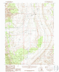
1987 Map of Sandy Creek Benches
USGS Topo · Published 1987About this map
Sandy Ranch sits at the heart of this high-desert landscape in the late 1980s, positioned where Sandy Creek flows between the dramatic elevations of Capitol Reef National Park and the surrounding tablelands. The terrain is defined by extreme relief, from the sharp descent at the Elbow of the Sandy to the narrow drainage of The Narrows. A network of deep canyons and washes, including North Coleman Canyon and Sheets Gulch, cut through the massive geologic formations of Wildcat Mesa and Tarantula Mesa. The map illustrates a remote grazing and transit landscape, where the wide Sandy Creek Benches provided vital flat ground for movement in an area otherwise dominated by the sheer verticality of the reef and mesas.
Find a feature on this map
21 named features on this map. Tap any name to fly to it.
Don’t see what you’re looking for? This feature index may not catch every label — zoom into the map to look around manually.
Map Details
Editions of this 1987 Sandy Creek Benches Map
This is the sole edition of this map. No revisions or reprints were ever made.
Other maps of this area

1885 · San Rafael
USGS Topo · 1:250,000

1885 · Fish Lake
USGS Topo · 1:250,000

1886 · Escalante
USGS Topo · 1:250,000

1886 · Henry Mountains
USGS Topo · 1:250,000

1892 · Henry Mountains
USGS Topo · 1:250,000

1896 · Fish Lake
USGS Topo · 1:250,000

1952 · Notom 4 SE
USGS Topo · 1:24,000

1952 · Notom 4 NW
USGS Topo · 1:24,000

1952 · Notom 4 SW
USGS Topo · 1:24,000

1952 · Notom 4 NE
USGS Topo · 1:24,000