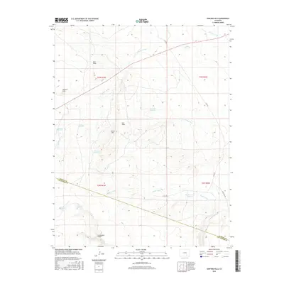
2016 Map of Sanford Hills
USGS Topo · Published 2016About this map
Blue Ridge and Haystack Butte anchor the high ground in this arid reach of the Colorado high plains. The landscape is defined by its seasonal water management, featuring a network of named reservoirs such as Mobley Reservoir, Davis Reservoir, and the Rock Dam Reservoir. These basins catch the intermittent flow of drainages like Saunders Arroyo and Twomile Arroyo before they descend toward the Apishapa River in the south. The terrain is marked by significant topographical shifts, from the Sanford Hills to the deep cut of Cottonwood Canyon. The presence of Lily Pond Spring and Cottonwood Spring suggests vital natural water sources in an area otherwise dominated by man-made catchments and ranching infrastructure. The county boundary between Pueblo and Las Animas counties cuts across the southern portion of the quadrangle, illustrating the geopolitical division of these sprawling rangelands.
Find a feature on this map
26 named features on this map. Tap any name to fly to it.
Don’t see what you’re looking for? This feature index may not catch every label — zoom into the map to look around manually.
Map Details
Editions of this 2016 Sanford Hills Map
This is the sole edition of this map. No revisions or reprints were ever made.
Other maps of this area

1891 · Apishapa
USGS Topo · 1:125,000

1893 · Apishapa
USGS Topo · 1:125,000

1897 · Apishapa
USGS Topo · 1:125,000

1954 · Trinidad
USGS Topo · 1:250,000

1955 · Trinidad
USGS Topo · 1:250,000

1958 · Trinidad
USGS Topo · 1:250,000

1959 · Trinidad
USGS Topo · 1:250,000
1970 · Red Top Ranch
USGS Topo · 1:24,000
1970 · Apishapa Bridge
USGS Topo · 1:24,000
1970 · Snowden Lake
USGS Topo · 1:24,000