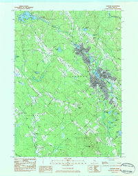
1983 Map of Sanford
USGS Topo · Published 1984About this map
The industrial and civic heart of Sanford and Springvale centers on the Mousam River during the early 1980s. This period shows a well-established urban core featuring significant local institutions like Nasson College, Goodall Mem Hosp, and the Goodall Libr. The river's influence on development is evident in the string of ponds—Mill Pond, Stump Pond, and No 1 Pond—that define the town's geography.
Find a feature on this map
62 named features on this map. Tap any name to fly to it.
Don’t see what you’re looking for? This feature index may not catch every label — zoom into the map to look around manually.
Map Details
Editions of this 1983 Sanford Map
2 editions found
Other maps of this area

1891 · Berwick
USGS Topo · 1:62,500

1891 · Kennebunk
USGS Topo · 1:62,500

1891 · Buxton
USGS Topo · 1:62,500

1891 · Newfield
USGS Topo · 1:62,500

1892 · Buxton
USGS Topo · 1:62,500

1893 · Kennebunk
USGS Topo · 1:62,500

1893 · Berwick
USGS Topo · 1:62,500

1893 · Buxton
USGS Topo · 1:62,500

1893 · Newfield
USGS Topo · 1:62,500

1898 · Kennebunk
USGS Topo · 1:62,500