1960 Map of Santa Ana
USGS Topo · Published 1960About this map
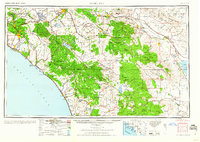
The Santa Ana region at mid-century reveals the evolving landscape of Southern California before the peak of suburban sprawl. Central to the map is the network of the Atchison Topeka and Santa Fe and Southern Pacific railroads, which linked established citrus-growing centers like Anaheim, Orange, and Fullerton to the broader regional economy. Military influence remains prominent during this post-war era, with the footprint of Camp Haan Mil Res and March Field south of Riverside.
Find a feature on this map
101 named features on this map. Tap any name to fly to it.
Don’t see what you’re looking for? This feature index may not catch every label — zoom into the map to look around manually.
Map Details
Editions of this 1960 Santa Ana Map
2 editions found

Other maps of this area

1893 · El Cajon
USGS Topo · 1:62,500

1893 · Oceanside
USGS Topo · 1:62,500

1893 · Escondido
USGS Topo · 1:62,500

1894 · Los Angeles
USGS Topo · 1:62,500

1894 · Pomona
USGS Topo · 1:62,500

1896 · Santa Ana
USGS Topo · 1:62,500

1896 · Pasadena
USGS Topo · 1:62,500

1896 · Anaheim
USGS Topo · 1:62,500

1896 · San Bernardino
USGS Topo · 1:62,500

1896 · Las Bolsas
USGS Topo · 1:62,500