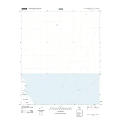
2012 Map of Santa Catalina East OE N
USGS Topo · Published 2012About this map
Santa Catalina Island meets the expanse of the Pacific Ocean along a stretch of northeastern coastline defined by protected coves and natural landmarks. The settlement at Whites Landing provides a rare point of human activity near White Cove, while the surrounding geography features prominent rises like Whitleys Peak and Hen Rock. This 2012 survey illustrates the maritime connectivity of the area, showing the established routes for the Ferry Crossing that link the island to the mainland.
Find a feature on this map
14 named features on this map. Tap any name to fly to it.
Don’t see what you’re looking for? This feature index may not catch every label — zoom into the map to look around manually.
Map Details
Editions of this 2012 Santa Catalina East OE N Map
This is the sole edition of this map. No revisions or reprints were ever made.
Other maps of this area

1896 · Las Bolsas
USGS Topo · 1:62,500

1896 · San Pedro
USGS Topo · 1:62,500

1901 · Southern California Sheet No. 1
USGS Topo · 1:250,000

1904 · Southern California Sheet No. 1
USGS Topo · 1:250,000
1941 · Las Bolsas
USGS Topo · 1:62,500
1943 · Las Bolsas
USGS Topo · 1:62,500

1943 · San Pedro
USGS Topo · 1:125,000

1943 · Santa Catalina North
USGS Topo · 1:24,000

1943 · Santa Catalina East
USGS Topo · 1:24,000

1943 · Santa Catalina South
USGS Topo · 1:24,000