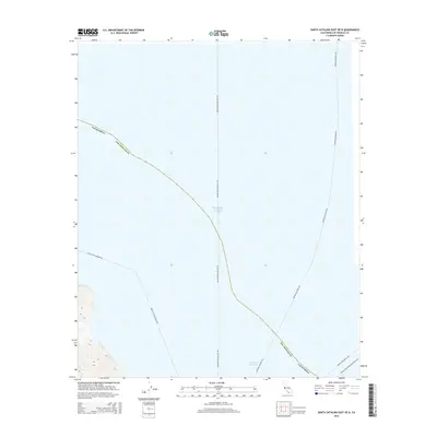
2015 Map of Santa Catalina East OE N
USGS Topo · Published 2015About this map
Pacific Ocean waters dominate this coastal survey, which documents the maritime transportation corridors connecting the California mainland to Santa Catalina Island. The map reveals the primary ferry routes radiating from the island, including the long-haul Avalon-Marina Del Rey Fry and the Avalon-San Pedro Fry. These designated transit lines trace the movement of people and supplies across the San Pedro Channel, illustrating the modern logistics of island life. While the topography on the southwestern edge shows the rise of island terrain, the primary focus is the watery expanse of Los Angeles County and the intersection of various ferry paths like the Avalon-Long Beach Fry and the Avalon-Two Harbors Fry.
Find a feature on this map
8 named features on this map. Tap any name to fly to it.
Don’t see what you’re looking for? This feature index may not catch every label — zoom into the map to look around manually.
Map Details
Editions of this 2015 Santa Catalina East OE N Map
This is the sole edition of this map. No revisions or reprints were ever made.
Other maps of this area

1896 · Las Bolsas
USGS Topo · 1:62,500

1896 · San Pedro
USGS Topo · 1:62,500

1901 · Southern California Sheet No. 1
USGS Topo · 1:250,000

1904 · Southern California Sheet No. 1
USGS Topo · 1:250,000
1941 · Las Bolsas
USGS Topo · 1:62,500
1943 · Las Bolsas
USGS Topo · 1:62,500

1943 · San Pedro
USGS Topo · 1:125,000

1943 · Santa Catalina North
USGS Topo · 1:24,000

1943 · Santa Catalina East
USGS Topo · 1:24,000

1943 · Santa Catalina South
USGS Topo · 1:24,000