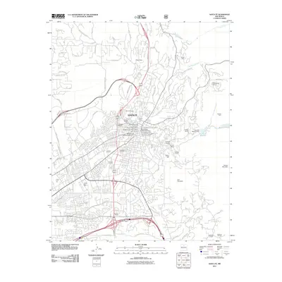
2011 Map of Santa Fe
USGS Topo · Published 2011About this map
Santa Fe is depicted here as a dense intersection of historic preservation and modern growth in northern New Mexico. The map provides a detailed view of the city's architectural legacy, featuring the Santa Fe Historic District and the Barrio de Analco Historic District. Preservation is further evidenced by several historic sites, including the Bridge of the Hidalgos Historic Site and the Don Gaspar Historic District. Cultural landscapes like the National Cemetery and Rosario Cemetery sit alongside working irrigation features such as the Acequie Madre, reflecting the community's centuries-old relationship with water management.
Find a feature on this map
95 named features on this map. Tap any name to fly to it.
Don’t see what you’re looking for? This feature index may not catch every label — zoom into the map to look around manually.
Map Details
Editions of this 2011 Santa Fe Map
This is the sole edition of this map. No revisions or reprints were ever made.
Other maps of this area

1889 · Santa Fe
USGS Topo · 1:125,000

1892 · Santa Clara
USGS Topo · 1:125,000

1894 · Santa Fe
USGS Topo · 1:125,000

1951 · Agua Fria
USGS Topo · 1:24,000

1951 · Turquoise Hill
USGS Topo · 1:24,000

1952 · Santa Fe
USGS Topo · 1:24,000

1952 · Turquoise Hill
USGS Topo · 1:24,000

1952 · Seton Village
USGS Topo · 1:24,000

1953 · Tesuque
USGS Topo · 1:24,000

1953 · Horcado Ranch
USGS Topo · 1:24,000