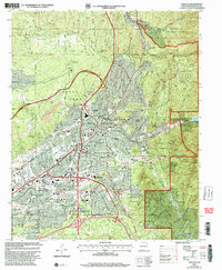
2002 Map of Santa Fe
USGS Topo · Published 2003About this map
The State Capital sits at the heart of this high-altitude landscape, where the urban grid of Santa Fe meets the rising foothills of the Santa Fe National Forest. This 2002 revision provides an intricate look at the city's civic and cultural footprint, featuring the Governors Mansion, the Federal Courthouse, and numerous educational institutions like St Johns College and the College of Santa Fe. The terrain is defined by a series of dry arroyos, including Arroyo de los Frijoles and Arroyo de los Chamisos, which channel seasonal runoff toward the Santa Fe River. To the east, the elevation climbs toward Atalaya Mountain and Sun Mountain, overlooking Nichols Reservoir. The map also documents the significant presence of the Santa Fe National Cemetery and the St Catherine Indian Sch, reflecting the complex layers of local history and institutional development at the turn of the 21st century.
Find a feature on this map
64 named features on this map. Tap any name to fly to it.
Don’t see what you’re looking for? This feature index may not catch every label — zoom into the map to look around manually.
Map Details
Editions of this 2002 Santa Fe Map
This is the sole edition of this map. No revisions or reprints were ever made.
Other maps of this area

1889 · Santa Fe
USGS Topo · 1:125,000

1892 · Santa Clara
USGS Topo · 1:125,000

1894 · Santa Fe
USGS Topo · 1:125,000

1951 · Agua Fria
USGS Topo · 1:24,000

1951 · Turquoise Hill
USGS Topo · 1:24,000

1952 · Santa Fe
USGS Topo · 1:24,000

1952 · Turquoise Hill
USGS Topo · 1:24,000

1952 · Seton Village
USGS Topo · 1:24,000

1953 · Tesuque
USGS Topo · 1:24,000

1953 · Horcado Ranch
USGS Topo · 1:24,000