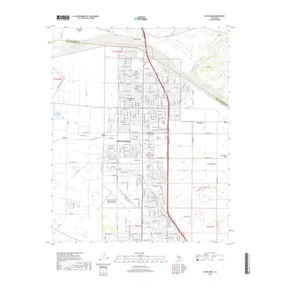
2018 Map of Santa Maria
USGS Topo · Published 2018About this map
Santa Maria and its surrounding agricultural valley appear here during a period of sustained urban expansion and institutional growth. The map illustrates a dense street grid that has moved well beyond the historic core, reaching toward the industrial and transit hubs at Midco and Rosemary. The southern reaches are defined by the expansive Santa Maria Public Airport, a landmark that reflects the region's aviation history and its role as a regional transportation center. Education and community life are anchored by the Allan Hancock College campus and the Santa Barbara Business College Santa Maria, while the northern boundary is marked by the wide, sandy bed of the Santa Maria River. This survey captures the transition from open ranch land to a structured municipal landscape, with smaller named localities like Pacer and Rex situated along the peripheral rail and road corridors that serve the valley's economy.
Find a feature on this map
134 named features on this map. Tap any name to fly to it.
Don’t see what you’re looking for? This feature index may not catch every label — zoom into the map to look around manually.
Map Details
Editions of this 2018 Santa Maria Map
This is the sole edition of this map. No revisions or reprints were ever made.
Other maps of this area

1897 · Arroyo Grande
USGS Topo · 1:62,500

1900 · San Luis
USGS Topo · 1:125,000

1905 · Guadalupe
USGS Topo · 1:125,000

1905 · Lompoc
USGS Topo · 1:125,000

1922 · Nipomo
USGS Topo · 1:62,500

1942 · Guadalupe
USGS Topo · 1:125,000

1942 · Lompoc
USGS Topo · 1:125,000

1942 · Arroyo Grande
USGS Topo · 1:62,500

1942 · Santa Maria
USGS Topo · 1:62,500

1942 · Point Sal
USGS Topo · 1:62,500