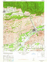
1964 Map of Santa Paula
USGS Topo · Published 1964About this map
The citrus groves and oil fields of Ventura County define this landscape, where the Santa Clara River separates the agricultural valley floor from the rising heights of Sulphur Mountain and South Mountain. This postwar-era map illustrates a period when the Ojai Valley and Santa Paula remained deeply tied to their resource-based economies. Industrial development is evident in the canyons, particularly at the Timber Canyon Oil Co and Texas Oil Co operations, while the valley floor is crisscrossed by irrigation features like the Ditch and the vital Southern Pacific railroad line.
Find a feature on this map
55 named features on this map. Tap any name to fly to it.
Don’t see what you’re looking for? This feature index may not catch every label — zoom into the map to look around manually.
Map Details
Editions of this 1964 Santa Paula Map
This is the sole edition of this map. No revisions or reprints were ever made.
Other maps of this area

1900 · Triunfo Pass
USGS Topo · 1:62,500

1900 · Piru
USGS Topo · 1:62,500

1903 · Santa Paula
USGS Topo · 1:62,500

1903 · Mt. Pinos
USGS Topo · 1:125,000

1903 · Tejon
USGS Topo · 1:125,000

1903 · Camulos
USGS Topo · 1:125,000

1904 · Ventura
USGS Topo · 1:62,500

1904 · Hueneme
USGS Topo · 1:62,500

1921 · Piru
USGS Topo · 1:62,500

1921 · Triunfo Pass
USGS Topo · 1:62,500