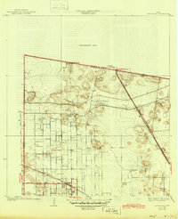
1933 Map of Santa Rosa
USGS Topo · Published 1945About this map
Santa Rosa serves as the primary hub for this agricultural landscape of the Rio Grande Valley as it appeared in the late 1920s. The town's layout is defined by the intersection of the Southern Pacific and Missouri Pacific railroads, reflecting the era's reliance on rail for transporting local produce. Beyond the town center, the map reveals a transition from organized irrigation and grid-patterned fields to more varied terrain dominated by large-scale cattle operations and family holdings such as Santa Rita Ranch and San Rafael Ranch. The infrastructure of the North Floodway carves across the northeastern quadrant, highlighting the region's managed drainage systems. Smaller outposts like Sebastian and El Cotillo Ranch punctuate the landscape, while the presence of the Santa Rosa West Road suggests the early development of a more robust local thoroughfare network.
Find a feature on this map
12 named features on this map. Tap any name to fly to it.
Don’t see what you’re looking for? This feature index may not catch every label — zoom into the map to look around manually.
Map Details
Editions of this 1933 Santa Rosa Map
3 editions found
Other maps of this area

1929 · Harlingen
USGS Topo · 1:24,000

1929 · Santa Rosa
USGS Topo · 1:24,000

1929 · La Feria
USGS Topo · 1:24,000

1932 · Combes
USGS Topo · 1:31,680

1932 · Harlingen
USGS Topo · 1:31,680

1933 · Santa Rosa
USGS Topo · 1:31,680

1936 · La Feria
USGS Topo · 1:31,680

1953 · Brownsville
USGS Topo · 1:250,000

1956 · San Perlita South
USGS Topo · 1:24,000

1956 · Santa Rosa
USGS Topo · 1:24,000
Featured Places
- Santa Rosa, TX
- Sebastian, TX
- S and C Colonia, TX
- Yznaga Number 1 Colonia, TX
- Tierra Bonita Number 2 Colonia, TX