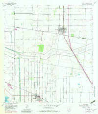
1956 Map of Santa Rosa
USGS Topo · Published 1983About this map
Agricultural development and flood control infrastructure dominate this landscape in the Rio Grande Valley, where the North Floodway and its Pilot Channel slice through the grid-patterned fields of the South Texas brush country. The settlement of Santa Rosa and the rail town of Sebastian serve as primary hubs, connected by the Missouri Pacific and Southern Pacific railroad lines. For local history researchers, the map identifies several significant burial sites, including Santa Rita Cem, Guadalupe Cem, and El Azadon Cem, which are often located near the intersections of local arteries like Cantu Road and Rabb Road. The presence of the Valley Acres Reservoir and numerous pumping stations highlights the intensive irrigation required for the region's farming economy, while names like San Rafael Cem reflect the deep cultural heritage of the communities situated along the Hidalgo, Willacy, and Cameron County lines.
Find a feature on this map
26 named features on this map. Tap any name to fly to it.
Don’t see what you’re looking for? This feature index may not catch every label — zoom into the map to look around manually.
Map Details
Editions of this 1956 Santa Rosa Map
3 editions found
Other maps of this area

1929 · Harlingen
USGS Topo · 1:24,000

1929 · Santa Rosa
USGS Topo · 1:24,000

1929 · La Feria
USGS Topo · 1:24,000

1932 · Combes
USGS Topo · 1:31,680

1932 · Harlingen
USGS Topo · 1:31,680

1933 · Santa Rosa
USGS Topo · 1:31,680

1936 · La Feria
USGS Topo · 1:31,680

1953 · Brownsville
USGS Topo · 1:250,000

1956 · San Perlita South
USGS Topo · 1:24,000

1956 · Santa Rosa
USGS Topo · 1:24,000
Featured Places
- Santa Rosa, TX
- Sebastian, TX
- S and C Colonia, TX
- Yznaga Number 1 Colonia, TX
- Tierra Bonita Number 2 Colonia, TX