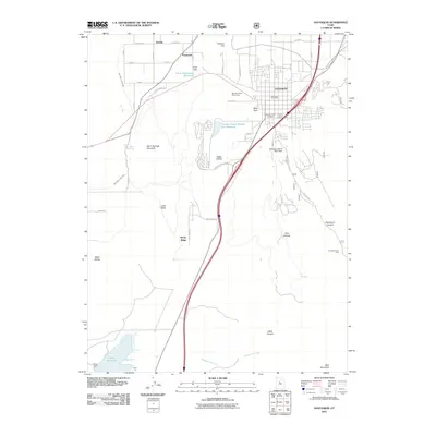
2011 Map of Santaquin
USGS Topo · Published 2011About this map
The town of Santaquin serves as the focal point of this 2011 survey, situated at the transition between the developed valley floor and the rising canyons of the Wasatch Front. The map highlights a complex water management system essential to this arid region, featuring the Ewell Regulating Reservoir and its associated Ewell Dam, alongside the Summit Creek Number Two Reservoir and Santaquin Debris Basin Dam. These structures, combined with the East Warm Creek Ditch, illustrate the infrastructure required to sustain the agricultural and residential communities of Genola and Townsend. To the south, the terrain drops toward the northern edge of Mona Reservoir, while the eastern portion of the sheet is dominated by the steep topography of Santaquin Canyon and Pole Canyon. Cultural landmarks such as the Santaquin City Cemetery and the Santaquin Post Office provide fixed points for local history and genealogical research.
Find a feature on this map
40 named features on this map. Tap any name to fly to it.
Don’t see what you’re looking for? This feature index may not catch every label — zoom into the map to look around manually.
Map Details
Editions of this 2011 Santaquin Map
This is the sole edition of this map. No revisions or reprints were ever made.
Other maps of this area

1885 · Salt Lake
USGS Topo · 1:250,000

1885 · Manti
USGS Topo · 1:250,000

1895 · Manti
USGS Topo · 1:250,000

1948 · Spanish Fork
USGS Topo · 1:24,000

1949 · Provo
USGS Topo · 1:62,500

1950 · Spanish Fork
USGS Topo · 1:24,000

1950 · West Mountain
USGS Topo · 1:24,000
1950 · Goshen Valley North
USGS Topo · 1:24,000
1950 · West Mountain
USGS Topo · 1:62,500

1951 · Santaquin
USGS Topo · 1:62,500