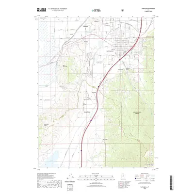
2020 Map of Santaquin
USGS Topo · Published 2020About this map
Santaquin and Genola define the landscape of this southern portion of the Goshen Valley, where the orchard-lined streets of the valley floor meet the rising peaks of the Wasatch Range. The settlement pattern follows the essential water management of the arid West, traced through the E Warm Cr Ditch and Warm Springs Ditch, which feed the surrounding agricultural fields. Significant elevation changes are evident as the terrain climbs from the Juab Valley into the protected lands of the Uinta National Forest, marked by deep cuts like Santaquin Canyon and Pole Canyon. Genealogists will find several burial grounds including Santaquin City Cem and Genola Cem, while the southern reaches of the map show the community of Rocky Ridge situated near the county line and the banks of the Mona Reservoir.
Find a feature on this map
75 named features on this map. Tap any name to fly to it.
Don’t see what you’re looking for? This feature index may not catch every label — zoom into the map to look around manually.
Map Details
Editions of this 2020 Santaquin Map
This is the sole edition of this map. No revisions or reprints were ever made.
Other maps of this area

1885 · Salt Lake
USGS Topo · 1:250,000

1885 · Manti
USGS Topo · 1:250,000

1895 · Manti
USGS Topo · 1:250,000

1948 · Spanish Fork
USGS Topo · 1:24,000

1949 · Provo
USGS Topo · 1:62,500

1950 · Spanish Fork
USGS Topo · 1:24,000

1950 · West Mountain
USGS Topo · 1:24,000
1950 · Goshen Valley North
USGS Topo · 1:24,000
1950 · West Mountain
USGS Topo · 1:62,500

1951 · Santaquin
USGS Topo · 1:62,500