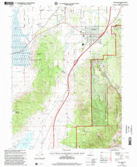
1998 Map of Santaquin
USGS Topo · Published 2002About this map
Santaquin sits at the junction of agricultural valleys and mountainous terrain during this 1998 revision by the USDA Forest Service. The settlement pattern reflects the importance of water management in the region, with the Strawberry Highline Canal and Goshen Valley Ditch drawing water across the landscape toward Genola and Townsend. The eastern portion of the sheet is dominated by the Uinta National Forest, where steep drainage features like Pole Canyon and Santaquin Canyon lead into the protected Mount Nebo Wilderness.
Find a feature on this map
41 named features on this map. Tap any name to fly to it.
Don’t see what you’re looking for? This feature index may not catch every label — zoom into the map to look around manually.
Map Details
Editions of this 1998 Santaquin Map
This is the sole edition of this map. No revisions or reprints were ever made.
Other maps of this area

1885 · Salt Lake
USGS Topo · 1:250,000

1885 · Manti
USGS Topo · 1:250,000

1895 · Manti
USGS Topo · 1:250,000

1948 · Spanish Fork
USGS Topo · 1:24,000

1949 · Provo
USGS Topo · 1:62,500

1950 · Spanish Fork
USGS Topo · 1:24,000

1950 · West Mountain
USGS Topo · 1:24,000
1950 · Goshen Valley North
USGS Topo · 1:24,000
1950 · West Mountain
USGS Topo · 1:62,500

1951 · Santaquin
USGS Topo · 1:62,500