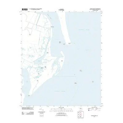
2011 Map of Santee Point
USGS Topo · Published 2011About this map
Quarantine marks the northern edge of this coastal landscape where the Intracoastal Waterway and Yawkey Way S thread through the salt marshes and maritime forests of Georgetown County. The intricate network of tidal channels includes Mosquito Creek, Lagoon Creek, and the Rockfish Canal, illustrating the complex hydrology of the lowcountry. Prominent landforms such as Cat Island, South Island, and the low elevation of Pine Ridge stand in contrast to the shifting sands of the North Breakers and South Breakers. Mariners and local historians will find the nautical context around the Winyah Bay Entrance particularly detailed, showing the relationship between offshore hazards like Mother Norton Shoal and the landmark at Cape San Roman. The transition from riverine outflow at North Santee Inlet to the open Atlantic Ocean reveals the dynamic nature of Santee Point.
Find a feature on this map
28 named features on this map. Tap any name to fly to it.
Don’t see what you’re looking for? This feature index may not catch every label — zoom into the map to look around manually.
Map Details
Editions of this 2011 Santee Point Map
This is the sole edition of this map. No revisions or reprints were ever made.
Other maps of this area

1942 · Cape Romain
USGS Topo · 1:24,000

1942 · Santee Point
USGS Topo · 1:24,000

1942 · North Island
USGS Topo · 1:24,000

1943 · Minim Island
USGS Topo · 1:24,000

1943 · Georgetown South
USGS Topo · 1:24,000

1947 · Georgetown South
USGS Topo · 1:24,000

1949 · Georgetown
USGS Topo · 1:250,000

1967 · Georgetown
USGS Topo · 1:250,000
1968 · Georgetown South
USGS Topo · 1:24,000

1974 · Georgetown
USGS Topo · 1:250,000