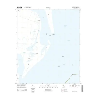
2014 Map of Santee Point
USGS Topo · Published 2014About this map
Quarantine stands as a solitary settlement marker on this coastal survey, positioned where the Atlantic waters meet the intricate marshes of South Island. The landscape is dominated by a complex network of waterways, including Rockfish Canal, Lagoon Creek, and Mosquito Cr, which weave through a series of significant landforms like Cat Island and North Island. These islands and shoals, such as Mother Norton Shoal and Fishing Bank, illustrate the dynamic nature of the South Carolina coastline near the Winyah Bay Entrance.
Find a feature on this map
31 named features on this map. Tap any name to fly to it.
Don’t see what you’re looking for? This feature index may not catch every label — zoom into the map to look around manually.
Map Details
Editions of this 2014 Santee Point Map
This is the sole edition of this map. No revisions or reprints were ever made.
Other maps of this area

1942 · Cape Romain
USGS Topo · 1:24,000

1942 · Santee Point
USGS Topo · 1:24,000

1942 · North Island
USGS Topo · 1:24,000

1943 · Minim Island
USGS Topo · 1:24,000

1943 · Georgetown South
USGS Topo · 1:24,000

1947 · Georgetown South
USGS Topo · 1:24,000

1949 · Georgetown
USGS Topo · 1:250,000

1967 · Georgetown
USGS Topo · 1:250,000
1968 · Georgetown South
USGS Topo · 1:24,000

1974 · Georgetown
USGS Topo · 1:250,000