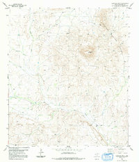
1983 Map of Santiago Peak
USGS Topo · Published 1991About this map
Santiago Peak dominates this arid high-desert landscape in Brewster County, rising sharply above the surrounding Santiago Mountains. The 1983 edition of the area reveals a terrain defined by hydraulic features and sparse human infrastructure, where survival depends on water sources like Santiago Windmill, a Spring, and various Tanks. The drainage patterns of Calamity Creek and Chalk Draw snake through the topography, illustrating the natural conduits that shape this part of the Trans-Pecos. Evidence of ranching and land use is anchored by Potter Ranch in the southern portion of the quadrangle. A network of 4wd tracks provides the primary means of traversal through the rocky flats and mountain passes, while scattered Drill Holes indicate historical resource exploration in this remote West Texas range.
Find a feature on this map
11 named features on this map. Tap any name to fly to it.
Don’t see what you’re looking for? This feature index may not catch every label — zoom into the map to look around manually.
Map Details
Editions of this 1983 Santiago Peak Map
2 editions found
Other maps of this area

1917 · Agua Fria
USGS Topo · 1:62,500

1917 · Santiago Peak
USGS Topo · 1:62,500

1917 · Buck Hill
USGS Topo · 1:62,500

1918 · Bone Spring
USGS Topo · 1:125,000

1918 · Buck Hill
USGS Topo · 1:62,500

1918 · Santiago Peak
USGS Topo · 1:62,500

1918 · Nine Point Mesa
USGS Topo · 1:62,500

1925 · Buck Hill
USGS Topo · 1:62,500

1937 · Nine Point Mesa
USGS Topo · 1:62,500

1937 · Agua Fria
USGS Topo · 1:62,500