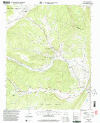
2002 Map of Sapello
USGS Topo · Published 2003About this map
Sapello and the surrounding canyon country of San Miguel County appear here in a landscape defined by the legacies of the Mora Grant and Las Vegas Grant. The map highlights a series of small, traditional settlements following the watercourses, including Manuelitas along Manuelitas Creek and Tierra Monte near Las Quebraditas. These communities are marked by local landmarks like the Brother of Jesus Mission and several family or community burial grounds such as San Ignacio Cem and the Soledad Cem. The terrain is characterized by deep canyons like Cañon del Medio and prominent ridges including Fragoso Ridge, illustrating how the early geography of northern New Mexico dictated the placement of mountain villages and ranching outposts far before modern development altered the region.
Find a feature on this map
37 named features on this map. Tap any name to fly to it.
Don’t see what you’re looking for? This feature index may not catch every label — zoom into the map to look around manually.
Map Details
Editions of this 2002 Sapello Map
This is the sole edition of this map. No revisions or reprints were ever made.
Other maps of this area

1889 · Las Vegas
USGS Topo · 1:125,000

1891 · Las Vegas
USGS Topo · 1:125,000

1893 · Las Vegas
USGS Topo · 1:125,000

1954 · Santa Fe
USGS Topo · 1:250,000

1958 · Santa Fe
USGS Topo · 1:250,000

1961 · El Porvenir
USGS Topo · 1:24,000

1961 · Montezuma
USGS Topo · 1:24,000

1963 · Lake Isabel
USGS Topo · 1:24,000

1963 · Rainsville
USGS Topo · 1:24,000
1963 · Las Vegas NW
USGS Topo · 1:24,000