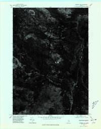
1975 Map of Saponac NE
USGS Topo · Published 1980About this map
Passadumkeag River meanders through this heavily forested portion of Penobscot County, shown here as it appeared in the mid-1970s. This orthophotoquad provides an unfiltered aerial perspective of the Maine woods, where the dense canopy is broken only by the winding river corridor and isolated clearing. The visual data highlights the intricate drainage patterns and boggy lowlands typical of the region's interior. Unlike traditional topographic maps, this imagery-based study reveals the specific timber density and the few primitive tracks or clearings that supported the local logging economy during this era, offering a distinct record of the landscape before decades of subsequent forest management and regrowth.
Find a feature on this map
1 named feature on this map. Tap any name to fly to it.
Don’t see what you’re looking for? This feature index may not catch every label — zoom into the map to look around manually.
Map Details
Editions of this 1975 Saponac NE Map
This is the sole edition of this map. No revisions or reprints were ever made.
Other maps of this area

1920 · Winn
USGS Topo · 1:62,500

1931 · Springfield
USGS Topo · 1:48,000

1931 · Saponac
USGS Topo · 1:48,000

1932 · Nicatous Lake
USGS Topo · 1:48,000

1934 · Saponac
USGS Topo · 1:62,500

1934 · Nicatous Lake
USGS Topo · 1:62,500

1934 · Springfield
USGS Topo · 1:62,500

1954 · Millinocket
USGS Topo · 1:250,000

1957 · Saponac
USGS Topo · 1:62,500

1958 · Millinocket
USGS Topo · 1:250,000