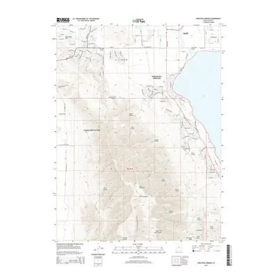
2014 Map of Saratoga Springs
USGS Topo · Published 2014About this map
Saratoga Springs and Eagle Mountain anchor this 2014 survey, illustrating a landscape defined by rapid residential expansion along the northwestern shores of Utah Lake. The map details the suburban grid systems pushing into the foothills of the Lake Mountains, where once-isolated terrain like Reformation Canyon and Israel Canyon now meet modern developments. To the north, the historic city of Lehi is connected to these newer settlements via Pony Express Pky and Redwood Rd, following routes that once served as vital territorial corridors.
Find a feature on this map
110 named features on this map. Tap any name to fly to it.
Don’t see what you’re looking for? This feature index may not catch every label — zoom into the map to look around manually.
Map Details
Editions of this 2014 Saratoga Springs Map
This is the sole edition of this map. No revisions or reprints were ever made.
Other maps of this area

1885 · Salt Lake
USGS Topo · 1:250,000

1885 · Tooele Valley
USGS Topo · 1:250,000

1915 · Fairfield
USGS Topo · 1:62,500

1917 · Fairfield
USGS Topo · 1:62,500

1947 · Fivemile Pass
USGS Topo · 1:62,500

1947 · Goshen Pass
USGS Topo · 1:24,000

1949 · Goshen Pass
USGS Topo · 1:24,000
1950 · Soldiers Pass
USGS Topo · 1:24,000

1950 · Pelican Point
USGS Topo · 1:24,000
1950 · Lincoln Point
USGS Topo · 1:24,000